Avis expert seisme 12 janvier 2010 en Haiti - CCR

PUBLICATIONS
Expert opinion: Earthquake in Haiti: what lessons are there for the West Indies?
On January 12, 2010 an earthquake with a magnitude of seven shook Haiti. Given CCR’s expertise in natural disasters, we are publishing a document in response to the event, which has been produced by our seismic simulation analyst.
02/02/2010
This initial "expert opinion" is the first in a series of occasional CCR publications aiming to reflect current events and highlight the lessons that can be learnt from the Haitian earthquake for the French West Indies, which are covered by France’s natural disaster compensation scheme.
Does the Haitian earthquake increase the occurrence probability of an earthquake in the French West Indies?
Given the distance of our territories (see below) and the local tectonic differences detailed later in this document, there is, in principle, no increase in the occurrence probability of an earthquake in the French West Indies. Although the same tectonic plates are involved on a large scale, a smaller scale reveals microplates moving against each other (Figure 1). Haiti and the French territories are not located on the
same microplates and thus do not interact directly.
However, it must not be forgotten that the probability of an earthquake in our West Indian territories is high independently of the Haitian earthquake. There have been two notable earthquakes in recent years: in Guadeloupe in 2004 and in Martinique in 2007.
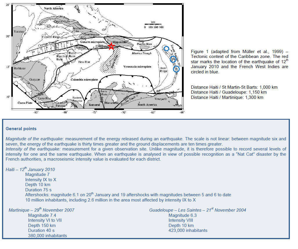
What is the tectonic context in Haiti?
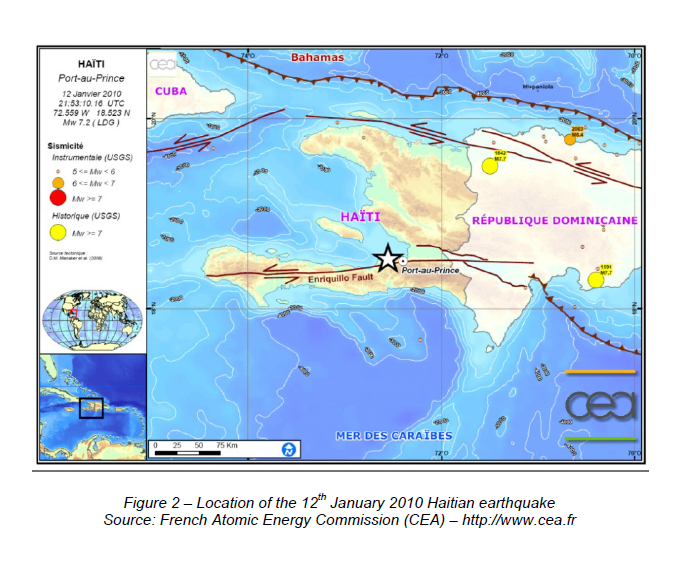
The area is at the boundary of two plates: the North American Plate and the Caribbean Plate, which collide. Some plate displacements are accommodated (absorbed) by a network of shallow faults. The 12th January earthquake was located on one of these faults, which covers over 300 km from the Dominican Republic and all over Haiti from east to west (Figure 2). This fault alone absorbs approximately 7 mm of the annual displacements between the two plates, which are estimated at 20 mm. A certain amount of displacement is accumulated by the fault until the rupture limit is reached, which results in an earthquake.
On 12th January, a 70 km long segment of the fault ruptured, with total displacements up to 2 meters locally.. This fault had not produced significant earthquakes in decades but may be the source of historic earthquakes such as the 1751 and 1770 earthquakes which already destroyed the city of Port-au-Prince.
As there has not been an earthquake reaching the magnitude 7 since 1770, the return period of the 12th January 2010 earthquake is estimated to be at least 200 years.
It is possible that the segments of the fault that did not rupture in January will produce earthquakes in future decades with magnitudes equal to or slightly above seven.
What is the tectonic context in the French West Indies?
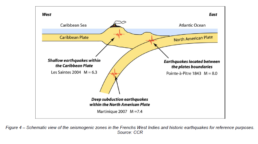
The French West Indies territories are located in the Lesser Antilles Arc where the tectonic plates are the same: the North American Plate and the Caribbean Plate. Yet in the case of the Lesser Antilles, the North American Plate dives under the Caribbean Plate (subduction). Subduction absorbs most of the relative displacements of the two plates. The fault is not visible since it is presumably located between 80 and 100 km eastward in the Atlantic Ocean.
As the distance between the fault and the islands is greater than in the case of Haiti, the intensity of a major earthquake with a magnitude equivalent to the Haitian earthquake would be lower. However, in the case of a subduction zone, it is possible to reach a greater magnitude than in Haiti, which could lead to similar intensity and therefore similar devastation.
What is the risk of a major earthquake in the French West Indies?
Pointe-à-Pitre had already been the victim in 1843 of a subduction earthquake with a magnitude estimated at 8 and an intensity comparable to the Haitian earthquake: IX.
Outside the subduction zone, there are many faults in the Caribbean Plate. These faults may have loading times (= accumulation of displacements until rupture) of several thousands of years. Some of thefaults have already ruptured, as during the earthquake in Les Saintes in 2004, therefore they are unlikely to be active for some time. However, the problem lies in the very many faults that have not yet released
the displacements accumulated over tens, hundreds or even thousands of years. These faults, not all of which have been identified, are close to urban areas and may produce earthquakes comparable to the Haitian earthquake.
To summarize, there is not one but three zones in the West Indies that may be the source of earthquakes comparable to the Haitian earthquake (Figure 4):
– Medium-depth earthquakes at the interface between the Caribbean Plate and the North American Plate, e.g. the destructive earthquake in Pointe-à-Pitre (1843);
– Deep-focus subduction earthquakes in the North American Plate, e.g. the earthquake in Martinique (2007), it being understood that much greater magnitudes may be reached;
– Earthquakes in the Caribbean Plate, which are lower in magnitude but much shallower and therefore have an equally high potential for destruction, e.g. the earthquake in Les Saintes (2004).
Could an earthquake trigger a volcanic eruption?
Magmatic chambers (reservoirs) of Mount Pelée (Martinique) and La Soufrière (Guadeloupe) are relatively shallow (a few km depth). The relationship between active faulting in the vicinity of these magmatic chambers and eruption has not yet been clearly identified.
It should be noticed that we are involved in a four-years research project called CASAVA, led by the Institut de Physique du Globe de Paris (IPGP) and funded by the Agence Nationale de la Recherche (ANR). During this project we will evaluate the volcanic hazard in Martinique and Guadeloupe considering the external sources triggering eruption like earthquake and the inferred hazards like flank collapse and tsunami.
Could an earthquake generate a tsunami in the West Indies?
In the case of earthquakes in the Caribbean Plate (Haiti or Les Saintes, 2004), a significant tsunami is unlikely to be triggered due to the inland location. For the earthquake in Haiti, a 12 cm tsunami was measured in Saint-Domingue (250 km from the epicentre).
The risk of tsunamis is greater with subduction earthquakes, particularly at the subduction interface between the two plates where the ocean is closer.
Paradoxically, it has instead been volcanoes that have caused the greatest tsunamis in living memory in the West Indies: Mount Pelée on Martinique in 1902 and the partial collapse of Soufrière Hills on Montserrat, 60 km northwest of Guadeloupe, in 1997. 3 to 6 m high waves were generated, swamping over 80 to 100 m of land. In comparison, the deadliest wave of the 2004 Indonesian earthquake measured 31 m high (in Lhoknga near Banda Aceh) and reached up to 1.5 km inland, making lasting changes to the coastline with 65 km² of land now submerged.

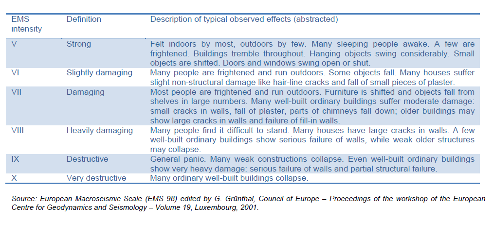
How is the intensity of an earthquake assessed?
The European Macroseismic Scale 1998 (EMS 98) is not continuous but comprises twelve grades describing the extent of damage. By way of an example, illustrations of certain grades and the description provided by the reference document are shown below.
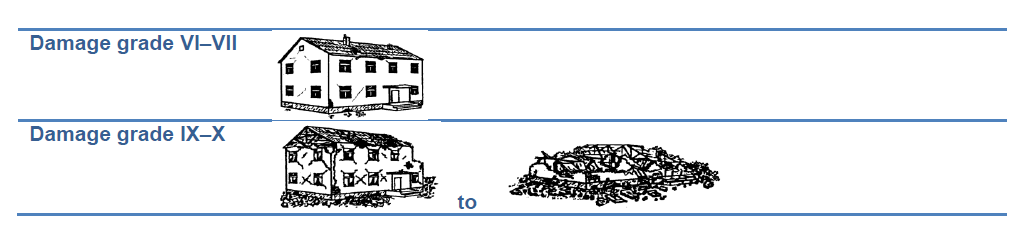
Damages in intermediate grades are understood as varying proportions of buildings that are affected, e.g. grade VIII intensity could equate to 1% of buildings destroyed whereas grade IX classification indicates that no less than 5% of buildings have been destroyed.
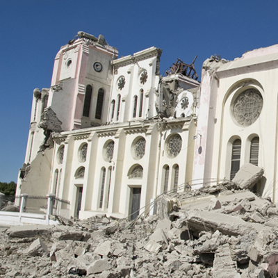
Vulnerability of buildings in Haiti
Constructions are highly vulnerable in Haiti because of the socioeconomic context. It is likely that much building work uses a high proportion of sand, as could easily be seen by the large cloud of dust over the city shortly after the earthquake. The concrete is poor quality and may fail to meet international earthquake-resistance standards. Even public or strategic buildings, such as the Presidential Palace,
were destroyed.
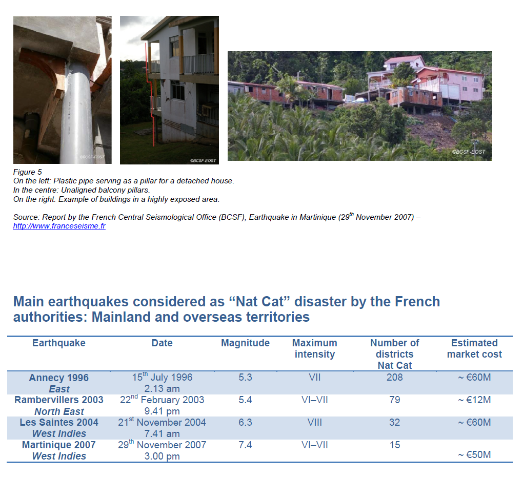
Vulnerability of buildings in the French West Indies
According to the investigation, following the November 2007 earthquake occurred offshore Martinique, which was conducted by the French Central Seismological Office (BCSF), buildings are particularly vulnerable in the French West Indies. The aggravating factors cited in the report include:
The following translation is just given as a friendly-reading purpose. Readers should refer to the original report in French if they want to go further in understanding the specificities of the French West Indies buildings vulnerability.
"Several aggravating factors can be identified in many constructions in both Martinique and Guadeloupe:
– Failure of countless buildings to comply with earthquake-resistance regulations, including after the effective date of the PS 92 codes (1995),
– A method of construction based on family networks and/or mutual assistance that too often fails to respect the basic principles of earthquake resistance for detached housing,
– The use of poor-quality materials (e.g. concrete),
– Frequent urbanisation in exposed areas (steep slopes, unstable ground, etc.),
– The weakening of many structures by the rainy season brought by the tropical trade winds from June to November (oxidation and corrosion of steel, breakdown of concrete, disintegration of mortar, nonwaterproof roofs and stonework in general). This is worse at altitude because of heavy rainfall."