Seisme de Charente Maritime - CCR

PUBLICATIONS
Earthquake in Charente Maritime (17) between La Rochelle and Rochefort on April 28, 2016 (8:46 a.m. local time)

An earthquake of a magnitude of 5.2 occurred on Thursday April 28, 2016 at 8:46 a.m. in the Charente-Maritime department, between La Rochelle and Rochefort.
05/11/2016
An earthquake of a magnitude of 5.2 occurred on Thursday April 28, 2016 at 8:46 a.m. in the Charente-Maritime department, between La Rochelle and Rochefort. The quake was largely felt in the western portion of the country.
A large earthquake occurred on Thursday April 28, 2016 at 8:46 a.m. between the urban agglomerations of La Rochelle and Rochefort. No doubt, the quake occurred relatively deep underground reaching a local magnitude of 5.2 (source: CEA/LDG). It was largely felt in the area around the epicenter and also throughout the western portion of the country. At 4:30 p.m., no considerable damage was to report aside from some cracks in the buildings near the epicenter.
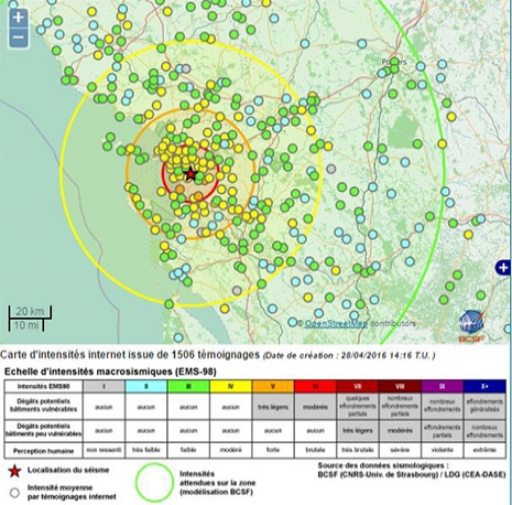
Internet map showing the intensity of the earthquake of April 28, 2016 (based on 1,506 testimonials) established by the French Central Seismological Office (BCSF, www.franceseisme.fr).
Magnitude of the earthquake
The magnitude of the earthquake is one of the highest recorded on the French mainland over the past twenty years. It is the highest recorded in the western portion of the country since the Oléron earthquake of 1972. The magnitude is comparable to that of the 2014 Barcelonnette earthquake or the Annecy quake of July 15, 1996.
Since 1962, only ten events of a magnitude greater or equivalent have been recorded on the French mainland.
Regional context
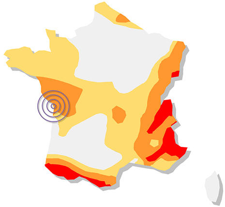
Plotting of the epicenter of the earthquake of April 28, 2016 as regards the French regulatory seismic zoning system.
The quake is located in a moderate seismic zone within the present seismic zoning system for France, in effect since 2011.
The seismic activity in this region is known and documented. For example a large earthquake struck the area near Angoulême in 1935 (see the associated data sheet on the SisFrance website).
Potentially active fault lines, running North-West – South-East, have been recorded in this region. It is no doubt one of these faults, of the system known as "Oléron", that was the cause of the April 28 earthquake.
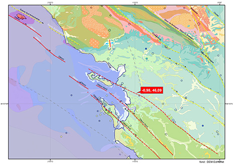
Location of the epicenter of the April 28, 2016 earthquake within the local geological context.
Possibility of aftershocks
At 4:30 p.m. on April 28, 2016, no reports of major aftershocks were recorded. However, historical records indicate that the region's seismic activity generally takes the form of local sequences (Oléron for example). Therefore, the possibility of aftershocks from the April 28 event cannot be excluded. The magnitude of these aftershocks are expected to regularly decrease. However, the occurrence of a major event, similar or more intense than any previous event recorded in this region, cannot be totally excluded at this stage.
Earthquake in Charente Maritime on April 28, 2016
An earthquake of a magnitude of 5.2 occurred on Thursday April 28, 2016 at 8:46 a.m. in the Charente-Maritime department, between La Rochelle and Rochefort.
Read online