SEISME DU 24 AOUT 2016 EN ITALIE - CCR

PUBLICATIONS
Earthquake in central Italy August 24, 2016
09/01/2016
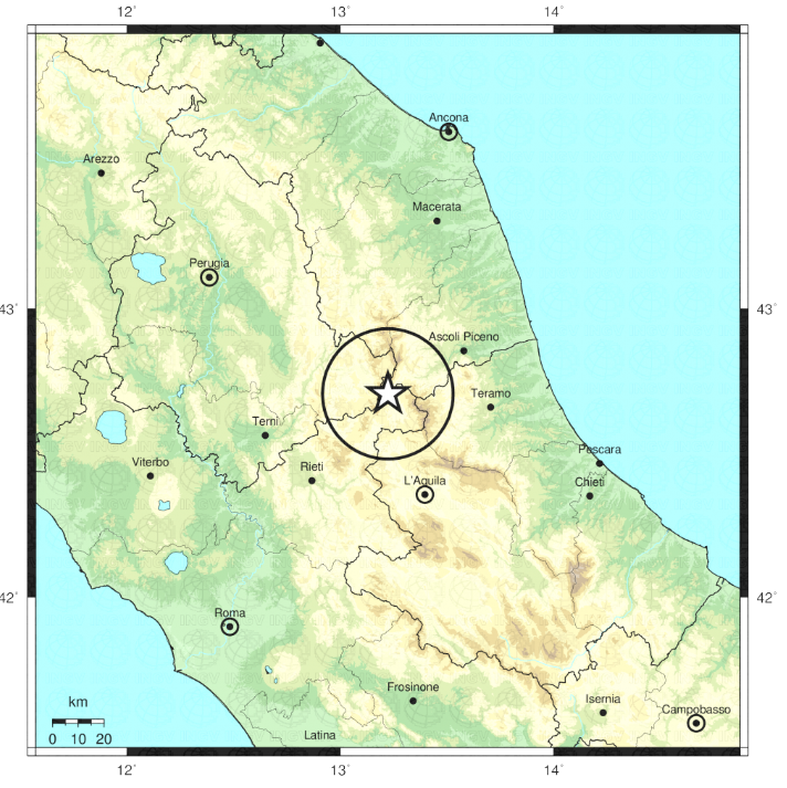
Seven years after the Aquila earthquake, the earth trembled once again in the center of Italy. On August 24, 2016 at 3.36 a.m., an earthquake of a magnitude of 6.0 struck the Apennines mountainous region. According to the Italian National Institute of Geophysics and Volcanology (INGV), the epicenter was located in the province of Rieti at a depth of 4 kilometers1.
FIGURE 1 : LOCALISATION OF THE EPICENTER (SOURCE : INGV)
Seismo-tectonic and historical context
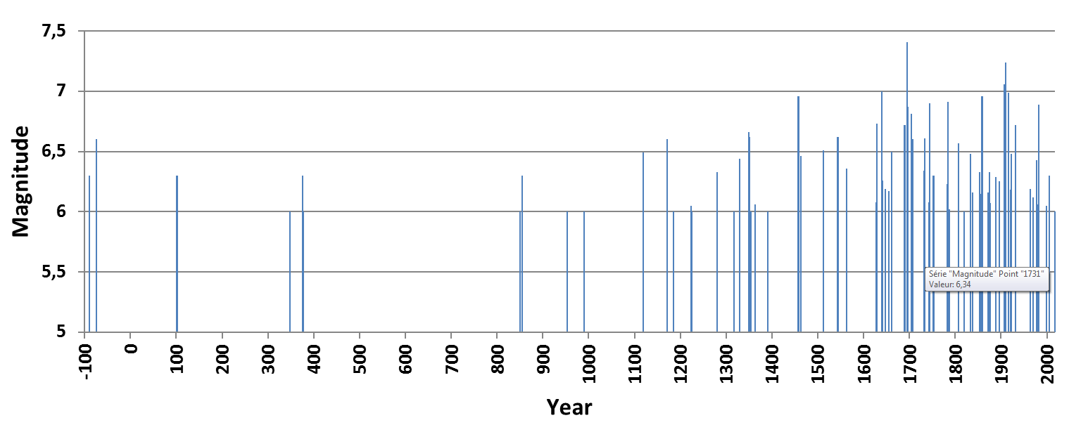
The earthquake occurred in the Apennines, a mountain chain of Central Italy formed as a result of the downward movement of the Adriatic plate under the Italian Peninsula. This region is geologically active with the presence of a well-identified fault system. It was one of these faults that caused the Aquila earthquake of April 6, 2009. The region, as is the case for all of Italy, is characterized by a history of highly frequent seismic activity (Figures 2 & 3). The most destructive events in this region occurred in 1349, 1461, 1639, 1646 and 1703 with estimated magnitudes ranging from 6.5 to 7.2 (INGV). The earthquake of January 14, 1703 was one of the most deadliest in the region with almost 6,000 fatalities2.
1 https://ingvterremoti.files.wordpress.com/2016/08/relazione_di_dettaglio_rieti_mw_6-0_del_2016-08-24_01_36_32_utc_versione_del_2016-08-24_ore_04_26_02_utc-1.pdf
2 General relation of the debris and fatalities caused by earthquakes occurring in Italy in 1703, Paris (in French), Guillaime Valleyre, edition of 1703.
FIGURE 2: MAIN EARTHQUAKES WITH A MAGNITUDE OVER 5 OCCURRED IN ITALY (SOURCE INGV)
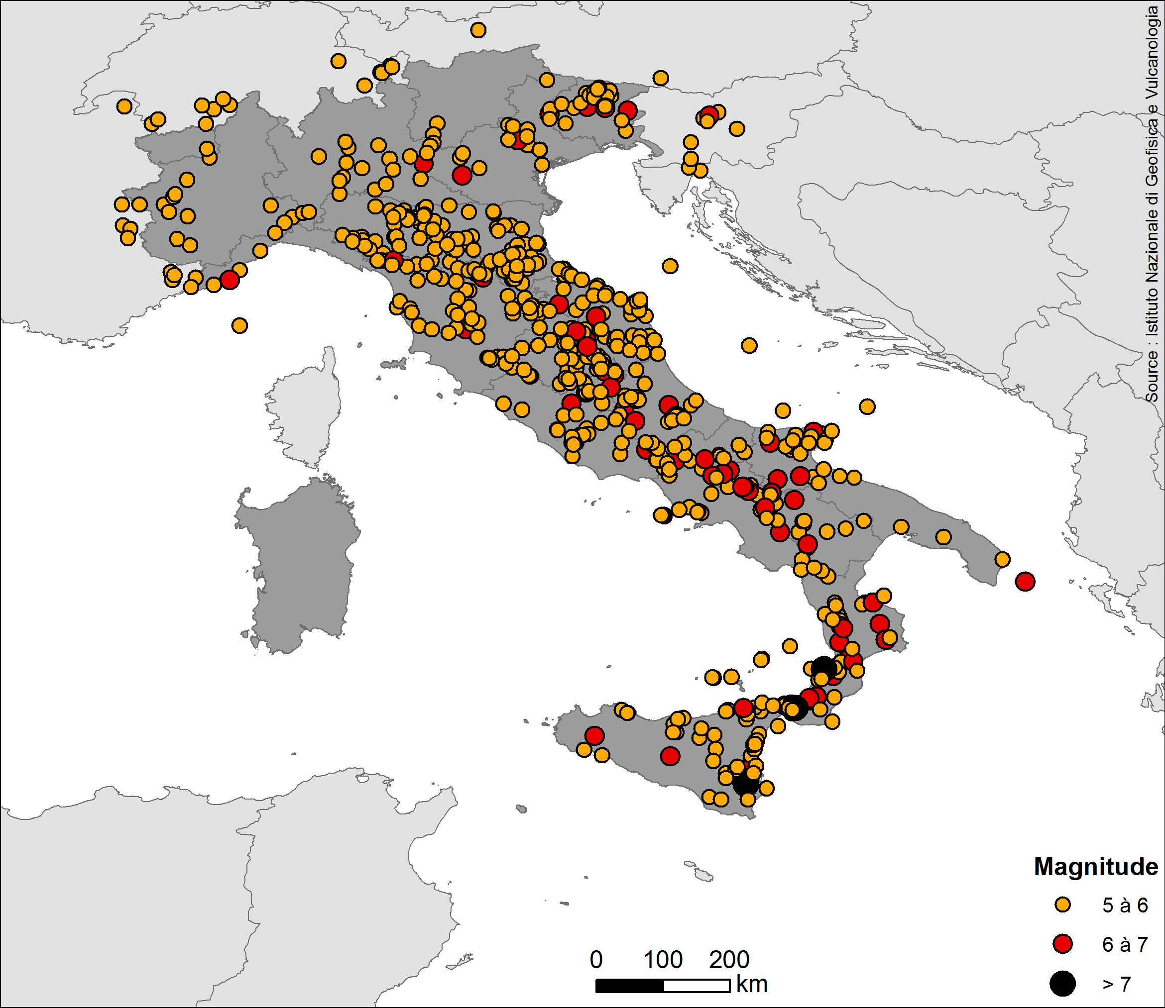
In 1915, the Fucino earthquake had a magnitude of 7. More recently, the region was particularly affected by the 1997 Umbria-Marche crisis (approximately 50 km to the northwest) during which thousands of tremors were recorded by local networks. Three main tremors of a magnitude of 5.5 or more occurred on the same type of faults oriented in the northwest-southeast direction. The zone was also severely affected at the time of the 2009 Aquila earthquake, located 30 kilometers to the southeast. This shallow earthquake with a magnitude of 6.3 had caused massive damages in the medieval town as well as 308 fatalities.
FIGURE 3 : EPICENTERS OF THE MAIN EARTHQUAKES AFFECTING ITALY (SINCE 100 B.C.)
Human and material consequences
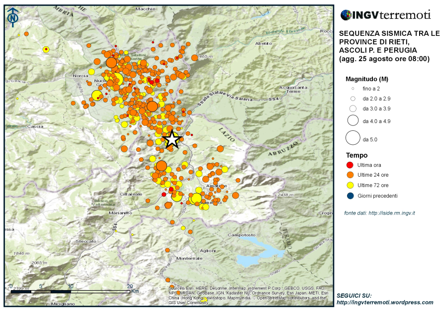
The municipalities most severely affected include Pescara del Tronto, Amatrice and Accumoli. The earthquake also affected the provinces of Perugia, Ascoli Piceno, Aquila and Teramo. Tremors were felt as far as Rome located 150 kilometers away. A significant number of aftershocks of a high magnitude occurred (Figure 4), some of which leveled buildings that had been damaged by the initial earthquake.
FIGURE 4: AFTERSHOCKS FROM THE EARTHQUAKE OF AUGUST 24, 2016 (SOURCE : INGV)
According to Italian civil defense authorities, the number of fatalities amounted to 290 on the morning of August 29, 2016. Due to the fact that the quake occurred at night, several people were buried under the rubble of their collapsed homes or buildings. Additionally, the occurrence of the earthquake at the height of the summer season and the attractiveness of the region to tourists appear to explain the significant loss of life.
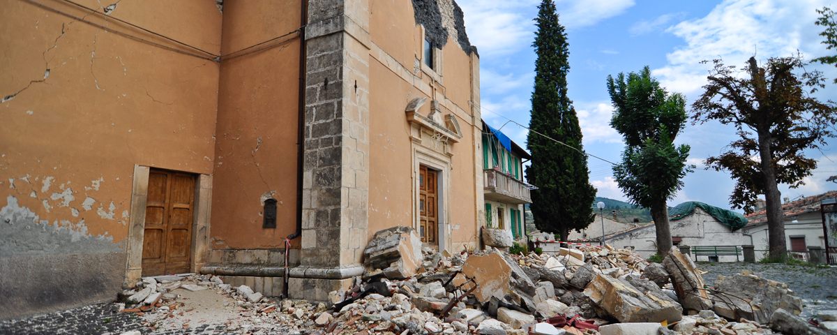
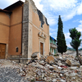
FIGURE 5 : AMATRICE: BEFORE AND AFTER THE EARTHQUAKE3
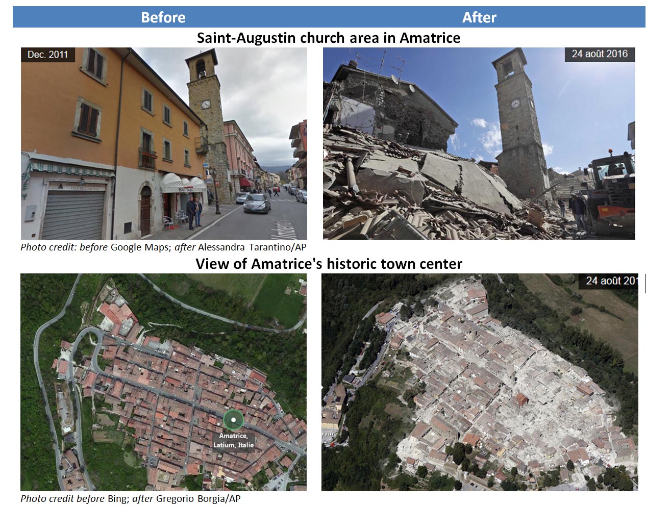
Several homes and buildings were destroyed and a large part of the historical and architectural heritage of the affected municipalities was hard hit (Figure 5). In Amatrice, buildings were destroyed within a zone covering three quarters of the municipality. The scale of the destruction is due to the magnitude of the event and to the shallow location of the epicenter but also to the vulnerability of the structures. In Italy, the majority of structures are built of traditional non-reinforced masonry (brick and rounded stone). In some instances, the masonry is reinforced using metal chaining. For more recent structures, reinforced concrete is used. Most structures were built prior to the introduction of building codes that require compliance with seismic standards. The risk of collapse during an earthquake of buildings erected before 1980 was therefore very high. For buildings erected between 1980 and 1996, the initial seismic standards were not very constraining and non-structural elements such as ceiling material, panels, chimneys or extensions were not considered at risk. Hence, buildings 20 to 30 years old also presented a high risk of collapse during a strong earthquake as well as a high risk of damage to non-structural elements in the event of a weaker earthquake.
3 http://www.lemonde.fr/planete/article/2016/08/25/avant-apres-les-batiments-detruits-par-le-seisme-en-italie_4988020_3244.html
The zone impacted by the August 24 earthquake included structures of a variety of designs and especially town centers predominantly comprised of old homes that were destroyed. These structures, located traditionally on headlands, were subjected to intense seismic activity due to phenomenon called "topographic site effects" for which seismic waves are trapped and release all their energy causing intermittent damages of severe proportions. In France, this phenomenon was observed in 1909 at the time of the Lambesc earthquake (for persons with access, an event data sheet is available on the Ceres extranet) where homes located atop hills were destroyed while those located at the base of the hills suffered less damage.
Comparison with the situation in France
While in France insured damages caused by earthquakes are covered under the natural disaster compensation scheme whenever the State recognizes the event as a natural disaster, in Italy earthquake coverage is not included in property policies subscribed by the general public (Table 1). It is generally included as an extension to fire insurance policies. However, this extension tends to result in a doubling of the premium amount . For business and industrial risks, earthquake coverage is made available by way of an additional premium that varies depending on the region, i.e. depending on the level of exposure. Given the low rate of subscription to this coverage, insured losses are generally insignificant when compared to overall economic losses, no more than a few percentage points.
TABLE 1: CHARACTERISTICS OF THE INSURANCE SYSTEM IN ITALY AND IN FRANCE
Characteristics |
Italy |
France |
Insurance system |
Private |
Combined |
Events covered |
Earthquake and consecutive fire |
Earthquake recognized as a natural disaster |
Guarantee |
Direct damages (business interruption is often excluded) |
Direct damages and consecutive business interruption losses |
Limit of the guaranty |
Weak (between 10% and 50% of insured amounts) |
Unlimited |
Deductible |
Between 1% and 2% of insured amounts |
€ 380 for private persons 10% of direct damages for professionals 3 working days for business interruption |
Rate |
Unrestricted. Varies depending on exposure, vulnerability and contractual terms |
Rate of fixed supplementary premium: 12% of the Property premium for the entire natural disaster guaranty |
Penetration rate |
Private persons: 5 to 10% Small and medium-sized companies: 10 to 30 % Large corporations: 100% |
99% on mainland France and over 50% in the overseas territories |
Reinsurance |
Private |
CCR with the State's guarantee and private reinsurance |
State intervention |
Legal obligation to provide reconstruction assistance |
Yes, after intervention of CCR reinsurance |
4 http://www.ilsole24ore.com/art/notizie/2012-05-30/quanto-costa-assicurare-propria-170822.shtml?uuid=AbPCNskF&refresh_ce=1
Hence, at the time of the 2009 Aquila earthquake, insured losses were estimated at € 500 million while the overall cost of reconstruction for the town of Aquila alone was estimated at € 15 billion. A large part of this amount was paid by the Italian government through exceptional State budget appropriations. It can be broken down between € 4.5 billion for private property and € 10 billion for public infrastructure .
In a press release dated August 26, 2016, Fitch estimated that insurers and reinsurers' losses could amount to between € 100 and € 200 million.
While seismic activity is spread over a larger area in France than in Italy, destructive earthquakes have occurred and will still occur on French territory. One example of this is the 1909 Lambesc earthquake that caused 46 deaths and would cause potential insured losses up to € 2 billion if it were to occur today (for persons with access, an event data sheet is available on the Ceres extranet). Another example is the 1843 earthquake in Guadeloupe that totally destroyed the town of Pointe-à-Pitre and for which the cost under the natural disaster compensation scheme would amount to € 1.5 billion today (CCR 2016 estimation, available on Ceres for persons with access, takes into account a penetration rate of 50% for overseas territories compared to almost 100% for mainland France).
However, since inception of the natural disaster compensation scheme in 1982, France has not been affected by a major earthquake. Indeed, only few of these events have been recorded over the recent past. The most noteworthy include (amounts adjusted to reflect 2014 euros):
- Annecy 1996, magnitude 5.3, depth 5 km – approximately € 110 m in losses;
- Les Saintes (Guadeloupe) 2004, magnitude 6.3, depth 15 km – € 85 m in losses;
- Martinique 2007, magnitude 7.4, but a depth of 150 km – € 70 m in losses;
- Rambervillers (Vosges) 2003, magnitude 5.4 depth 10 km – € 20 m in losses.
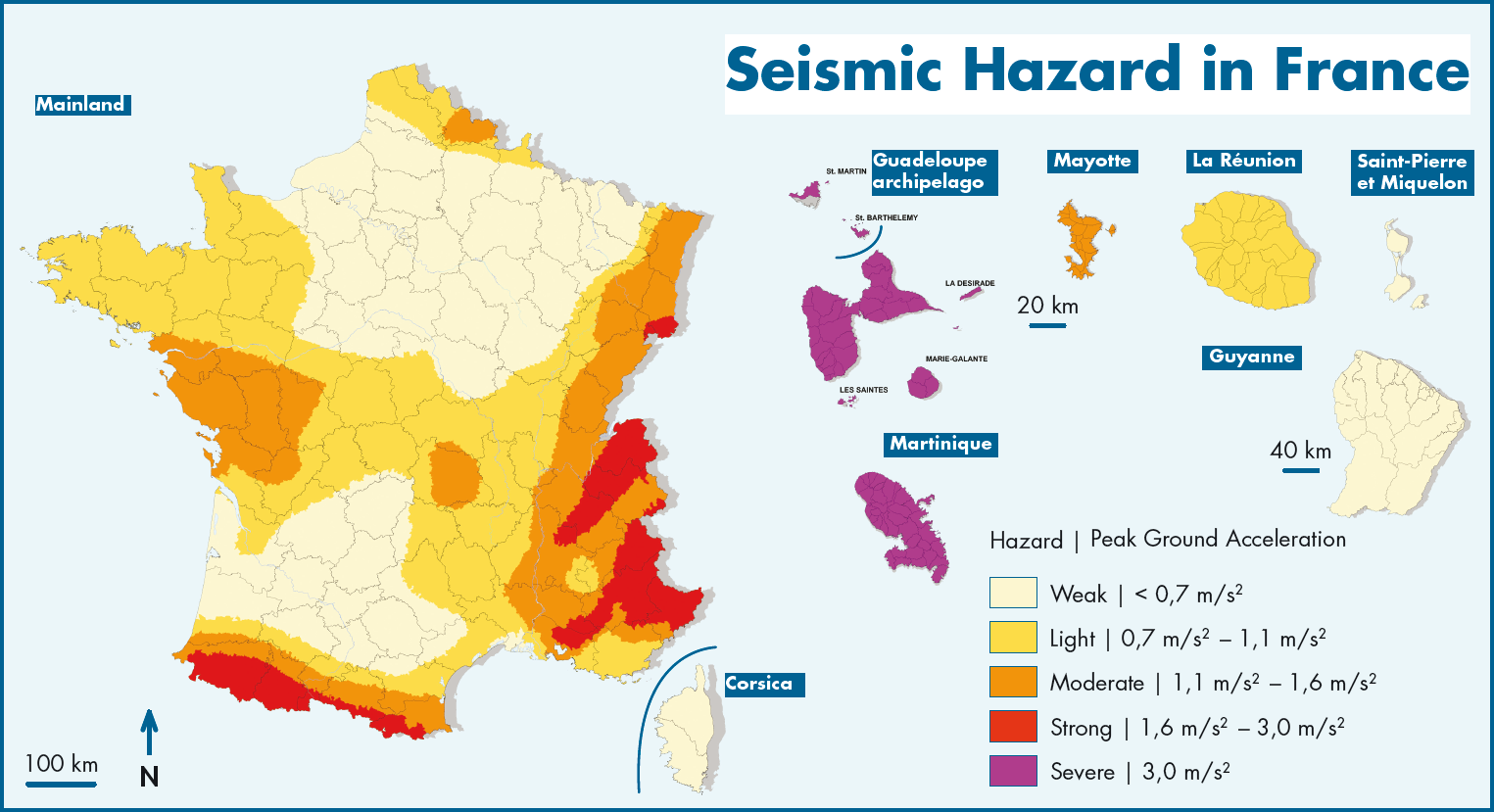
Although the frequency of earthquakes is less significant in France than in Italy, a magnitude of 6.0 may easily be reached in the most exposed regions of France: French Antilles, Internal Alps, Pyrenees and French Riviera (Figure 6).
5 Sigma, Swiss Re, No 1/2010, Natural catastrophes and man-made disasters in 2009
6 http://ilcentro.gelocal.it/laquila/cronaca/2011/06/24/news/di-stefano-per-ricostruire-la-citta-servono-14-miliardi-1.4878891
FIGURE 6 : REGULATORY EARTHQUAKE HAZARD IN FRANCE
In the framework of its efforts to analyze the exposure of the territory of France to natural disasters, CCR established an outline of earthquake exposure by cross-referencing the regulatory earthquake hazard map with information from its "market reinsurance" portfolio. The findings presented in table 2 underscore that, in the 2,000 municipalities located in the zones at high and average risk, there are:
- approximately 4 million residents insuring over 3 million dwellings policies for an aggregate insured capital amount of approximately € 650 billion;
- over 400,000 businesses with aggregate insured capital of over € 420 billion.
TABLE 2: ANALYSIS OF EARTHQUAKE RISK EXPOSURE (PERSONS AND INSURED PROPERTIES) IN FRANCE
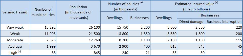
(a) CCR estimates
(b) Studies conducted by the Commissioner general for sustainable development (Commissariat Général au Développement développement durable - CGDD) in 2007 and 2014, indicate that the insurance penetration rate is substantially lower in the overseas territories (40% to 55% in the Antilles) compared to the mainland where the penetration rate is near 100%.
France and Italy share a history and methods of construction that are very similar. This is especially evident in the southeast part of France where certain territories, notably the County of Nice, were attached to Italy up until the XIXth century. One may note a certain resemblance between the villages of the Apennines, impacted by the August 24 earthquake, and the villages of Nice's back country scattered along very mountainous terrain. As is the case in Italy, French seismic standards have only recently been instated and for the large majority of French real estate built prior to 1990, excluding public domain structures, it may be considered that buildings do comply with general standards yet there is no application of specific seismic standards. As French and Italian buildings are similar from a construction perspective, the same level of damage could be sustained on French territory should a similar earthquake strike France.
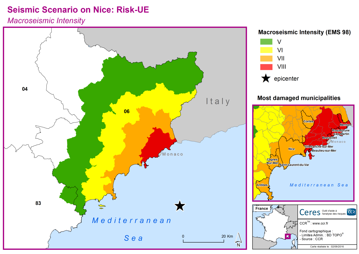
As an example, in 2014, the CCR R&D / Modeling team established an estimate of losses incurring from an earthquake that would impact the Nice region. This earthquake scenario was based on the Ligure earthquake of February 23, 1887 whose epicenter was located in the Gulf of Genoa near the French-Italian border. The quake was felt up to 600 kilometers away and caused significant damage from Nice to Menton as well as in all of the back country of the present-day Alpes-Maritimes department. If it were to occur today, this earthquake scenario of a magnitude of 6.3 and a depth of 8 kilometers, located 30 kilometers offshore Nice (Figure 7), would generate insured losses of € 11 to € 14 billion (for persons with access, an event data sheet is available on the Ceres extranet).
FIGURE 7: IMPACT OF AN EARTHQUAKE OF A 6.3 MAGNITUDE LOCATED OFFSHORE NICE
In an effort to enhance its knowledge of earthquake risk in France, CCR, in the framework of its multi-annual partnership with the French Geology and Mining Research Institute (Bureau de Recherches Géologiques et Minières - BRGM), is developing a model aimed at determining exposure to earthquake risk by quantifying the vulnerability of the territories through simulation of earthquake scenarios and their impact especially on the natural disaster compensation scheme.
Earthquake in central Italy August 24, 2016
Seven years after the Aquila earthquake, the earth trembled once again in the center of Italy. On August 24, 2016 at 3.36 a.m.
Read online